Written by chief forecaster at Severe Weather Updates (qualified).
So far Winter 2023-2024 has been rather mild, wet and stormy across the UK. There have been 9 named storms so far this storm season, extensive flooding in many areas and record breaking mild weather around Christmas time.
Things have changed now though, with colder easterly winds currently affecting much of the UK and Ireland. A cold easterly wind yesterday, on the 8th of January, produced widespread snow flurries in the South of the UK with heavier snow affecting higher parts of Kent and Sussex. 5cm (2 inches) of snowfall fell in Ide hill, West Kent.
The snow flurries have now moved away and the UK is under a cold and frosty air mass. This will likely be the case for the remainder of this week. Temperatures will lift up a little on Thursday and Friday before turning colder again into the weekend. Some hard overnight frosts are likely on Friday, Saturday and Sunday night with overnight lows widely below freezing and perhaps as low as -10C in some rural parts of Scotland and Northern England.
A northerly wind is then anticipated to arrive into Sunday and the start of next week. This is likely to introduce colder air still. By Tuesday some inland and northern areas may struggle to reach highs of 0C, with highs of 2-5C more typical for central and southern areas.
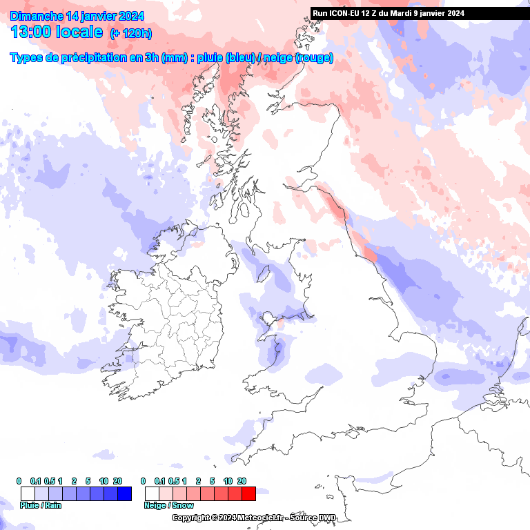
There will also be a few wintry showers around, particularly on Sunday night when there is the possibility that a band of light sleet and snow could affect more central areas of England and Wales. This is as the cold air pushing south into the UK brings with it a cold front which may contain some wintry precipitation. The following chart from meteociel.fr showers rain (blue) and snow (red) showers moving into northern areas on Sunday evening. Northern Scotland, North Wales, and the North Sea coast are most at risk of snow showers on Sunday night.
This is only a potential band of snow, therefore any refined details remain uncertain at this early stage. We will keep an eye on the data and update our page / blog in due course.
There also looks to be a few wintry showers around coasts, particularly coasts of Scotland, Ireland, Wales and perhaps also the North Sea. Places like the Highlands, Welsh Hills and North York Moors may see a covering of snowfall. However, it will likely be cold enough for snow to lower levels at this stage. So although the details are uncertain, there is a risk of a covering of snow to lower levels along the North Sea and East Anglia coast, as well as the coasts of Scotland, the West Wales coast and Irish coastal areas.
Inland areas of England and Wales will probably be on the dry side early next week – with most of the shower action around coastal areas as mentioned. However, a few surprises can’t be ruled out as this will be a cold flow and could produce the odd snow shower just about anywhere. Although, most areas will be very cold and dry with highs generally between -1C and 4C from North to South across the UK.
As we progress towards the remainder of the week, things look pretty interesting. The Atlantic does look to make some attempts to introduce milder air into the UK. However, with such an established cold pool over the UK, there is a risk that any attempt to bring in milder air from the South West could bring with it a risk of significant snowfall. Some temporary milder incursions are also possible across central and southern areas of the UK next week. The following chart is from the ECMWF weather model and showers colder air across Europe next Wednesday. Can you pick out the UK?
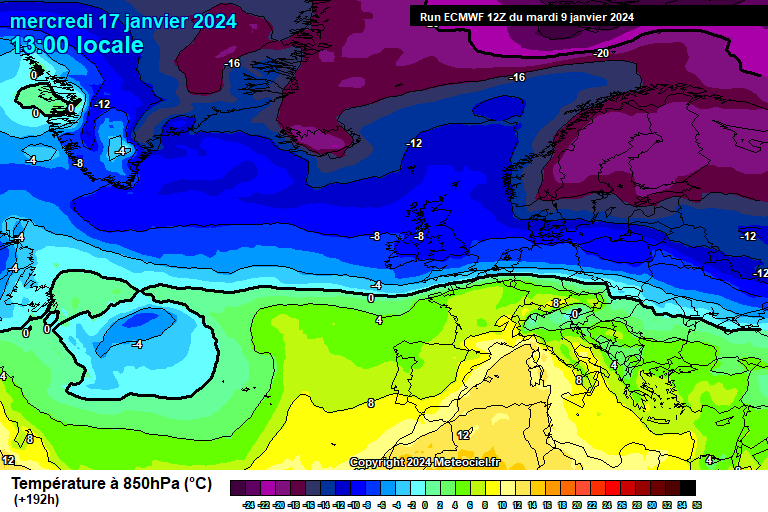
This is *not* a prediction of snow, merely making the statement that things look interesting for potential snow risk across the UK later next week, and the South of the UK is not discounted from this risk either. A few charts and models show upwards of 20cm (8 inches) in places, however these could either be very correct or very wrong, specific details can only be given with confidence until much nearer the time. The risk can not be discounted either as the set up next week has potential to deliver very significant snowfall due to the placement of very cold air over the UK and attempts of milder air to move up from the Atlantic area.
So the risk of heavy and significant snowfall for the UK next week is certainly a lot higher than normal, however it’s way to far out to give any specific details such as where it will snow, when and how much. This is because the position of the weather systems responsible for the snow risk is still uncertain.
Before then, enjoy the quiet and cold weather this week because it looks like things could become very eventful next week.
You can use our UK Snow Tracker to see the location of rain, sleet and snow live in the UK to a high accuracy and also the risk of snow within the next 5 days.