Storm Jocelyn has been declared by Met Eireann (Irish meteorological agency) for tomorrow night.
Storm Jocelyn is expected to move in from the Atlantic during the late part of tomorrow and into the early hours of Wednesday. Although is must be noted that this coming storm wont be as strong as Storm Isha, with winds on average around 10mph less across the country.
That being said, that is still enough for 50-60mph widely across England and Wales. Gusts are likely to be stronger for Cumbria, North Yorkshire, Northern Ireland and Scotland where widely gusts of 60-70mph are likely from around 6pm tomorrow night. In general anywhere North of Leeds could see gusts over 60mph with South of Leeds generally 50mph. The central belt of Scotland is likely to be a spot for 70mph+ gusts during tomorrow evening. This will last through much of the night with winds only gradually calming down through Wednesday morning.
The maximum forecast wind speeds from Jocelyn are expected to be around 80mph and this is likely to occur around coastal or higher parts of Western Scotland.
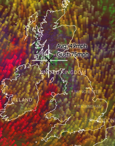
The following image from our Live Severe Weather Tracker shows forecast conditions for 11pm on Tuesday. You can use the tracker to monitor live and forecast wind speeds. Scroll through the hours and click on an hour to bring up a map for that time period.
Winds will eventually ease into Wednesday however will likely remain quite strong in the North during Wednesday morning rushour which could lead to further issues.
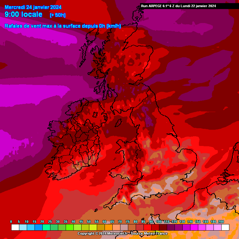
The following image shows maximum predicted gusts from storm Jocelyn. The red colors indicate around 50mph, with dark red 60mph and purples 70mph and above.
So certainly a very active low pressure system, enough so to be a named storm, however nothing out of the ordinary for the time of year.