Welcome to Severe Weather Updates blog.
Blog Issued by chief forecaster at Severe Weather Updates (qualified).
Some significantly colder than average weather is set to arrive in the UK from Sunday onwards. Temperatures will drop from the North on Sunday evening producing a widespread, in places hard frost on Monday morning with minimum temperatures down to -5C in places.
You can track the movement of cold air on our UK Weather Map, click on temperature and scroll to the right and click on the specified hour.
Initially on Sunday evening and through Monday wintry showers will be confined to Northern and Western coasts. Specifically, Northern Scotland, Northern Ireland and perhaps Western parts of Wales. Around 2-5cm of snowfall is likely fairly widely in Northern Scotland and Northern Ireland with 5-10cm on hills. Temperatures will also be very cold across the country on Monday with highs of 0-3C in the North and 1-6C in the South. However, away from these Northern and Western coasts, Sunday and Monday are likely to be mostly on the dry side.
Risk of Snow in the North on Monday night / Tuesday, perhaps further South too?
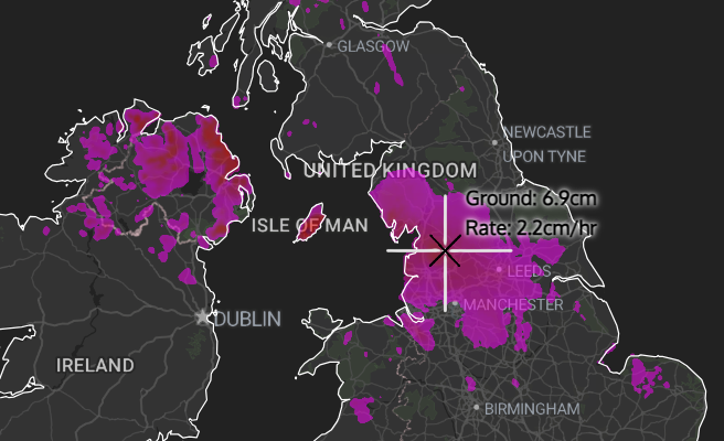
On Monday night into Tuesday, an area of low pressure has the potential to move out of Iceland and towards the UK. This increases the risk of snowfall in places especially in the North of the UK. However, it’s too early to say exactly where and how intense this snowfall will be. The risk of snow further south from this system can’t be ruled out either. Our UK Weather Map shows around 2-7cm of snowfall widely in the North on Tuesday morning, however this can’t be taken as definite and an exact snow forecast can’t be given at this stage. Further updates will be posted nearer the time on this potential.
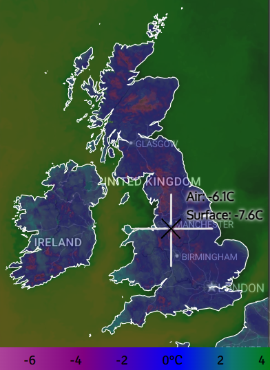
The following chart shows temperatures predicted by our UK Weather Map tracker for Monday morning. Most nights next week will be equally cold with temperatures regularly down below -5C fairly widely inland, producing a high risk of ice.
The next risk of snowfall, Wednesday and into Thursday.
The next risk of snowfall which we are monitoring is for Wednesday and into Thursday. Once the cold air becomes established across the UK, it appears that two separate areas of low pressure will try to make inroads into the UK. This ofcourse develops the risk of snowfall in places. Again, exact details can’t be provided at this stage. However, it must be noted that there is a continued risk of snowfall during this period, this risk becoming increasingly noted for more southern parts of the UK.
The remainder of the week, cold with snow flurries in places.
The remainder of next week, into the weekend, looks cold. Temperatures could become very cold at night with lows fairly widely below -8C, perhaps as low as -12C in a few places. Daytime highs are likely to range between 0C and 2C in the North and between 0C and 5C in the South. Again, there is a continued risk of a few snow flurries right through to next weekend as a colder northerly wind develops across the UK once again.
So to summarize, a cold outlook is facing the UK for next week. There is a risk of snowfall in the North on Monday and Tuesday night, and also in the South later in the week. Specific details regarding these snowfall risks can’t be given at this stage, however it does look possible that the snow risk earlier in the week starts in the South before more Southern areas need to note a risk of snowfall later in the week. Any updates will be posted nearer the time. You can track the snow risk in your area on our Live Snow Tracker.